General Overview
Pool 10 of the Upper Mississippi River (UMR) is the area between Lock and Dam 10 at river mile 615, at Guttenberg, Iowa, and Lock and Dam 9 at river mile 648, near Lynxville, Wisconsin. Pool 10 includes portions of the Upper Mississippi River National Wildlife Refuge and Fish Refuge, Effigy Mounds National Monument, Pikes Peak State Park (Iowa), Wyaslusing State Park (Wisconsin), and Yellow River State Forest (Iowa). Several Populated areas along the river include the cities of Prairie du Chien, Wisconsin and Guttenberg, Iowa, the towns of Harper’s Ferry and McGregor, Iowa, and the village of Bagley, Wisconsin.
Primary Response Goals
1. In general, any spilled oil product should be diverted and kept in the main channel of the Mississippi River. Then, if possible, the oil should be diverted with boom and collection should take place on the Minnesota shore
2. Three areas are designated as critical mussel habitat by the US FWS. Consult with resource managers to keep spilled product or response actions from affecting the substrate in these areas.
3. Keeping product out of the three closed areas is a top priority in any spill event. Due to seasonal high waterfowl use, deflection and exclusion booming of multiple opening and channels should be prioritized as a response tactic
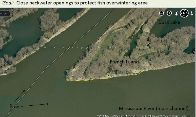
To further explain the techniques used above, refer to the image below labeled 619a – French Island in the GRP. The strategy for this location is to boom shore to shore to protect the fish overwintering area.
If a spill occurs, it is essential to notify federal, state, and local authorities within 24-hours of the spill. To inform federal authorities, call the National Response Center (NRC) at (800) 424-8802. To contact state authorities in Wisconsin, please call (800) 943-0003. To reach state authorities in Iowa, please call (515) 725-8694. To contact local authorities, please call 911. For more detailed information, refer to the Upper Mississippi River Spill Response Plan.
Click to Download Pool 10 GRP
The Upper Mississippi River Pool 10 Geographic Response Plan is available to download as a ZIP file. To download the files to use them locally, click on the link above. The download should start automatically, or your browser will prompt you to approve and save the file. The ZIP file is 82 MB, so it may take between 10-20 minutes to download depending on your Internet speed. Once the file is downloaded, unzip the files and open the Pool10_GRP.exe file.
Other Pools