General Overview
Pool 19 of the Upper Mississippi River (UMR) is the area traversing 46.2 miles between Lock and Dam 18 at river mile 410.5, near Gladstone, Illinois, and Lock and Dam 19 at river mile 364.3, at Keokuk, Iowa. The elevation of the pool at Lock and Dam 18 is 528 feet dropping ten feet to 518 feet at Lock and Dam 19. Pool 19 includes a portion of the Oquawka State Wildlife Refuge, state parks and recreation areas, as well as the Iowa State Penitentiary. However, most of the land along the river is private and its primary use is agricultural. The cities of Burlington, Fort Madison, and Keokuk, Iowa, and Dallas City, Nauvoo, and Hamilton, Illinois, lie along the river.
Primary Response Goals :
1. In general, any spilled oil product should be excluded from backwaters and kept in the main channel of the Mississippi River. Then, if possible, the oil should be diverted with boom and collected. Most collection sites are near boat landings.
2. Keeping product out of key backwater areas is the top priority in any spill event. Of primary concern are Blackhawk Bottoms, Burlington Island, Crystal Lake backwaters, as well as the aquatic vegetation beds above Montrose.
3. A spill or release should be collected as near to the source as possible, as there are few good collection locations. Also, the lower Pool is predominately good quality mussel beds with shallow, sandy substrate.
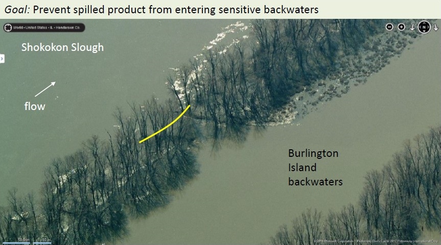
To further explain the techniques used above, refer to the image below labeled 399b – Burlington Island 2 in the GRP. The strategy for this location is to boom the opening between the two islands to prevent the spilled product form entering the Burlington Island backwaters.
If a spill occurs, it is essential to notify federal, state, and local authorities within 24-hours of the spill. To inform federal authorities, call the National Response Center (NRC) at (800) 424-8802. To contact state authorities in Illinois, please call (217) 782-7860. To reach state authorities in Iowa, please call (515) 725-8694. To contact local authorities, please call 911. For more detailed information, refer to the Upper Mississippi River Spill Response Plan.
The Upper Mississippi River Pool 19 Geographic Response Plan is available to download as a ZIP file. To download the files to use them locally, click on the link above. The download should start automatically, or your browser will prompt you to approve and save the file. The ZIP file is 256 MB, so it may take between 10-20 minutes to download depending on your Internet speed. Once the file is downloaded, unzip the files and open the Pool19_GRP.exe file.
Other Pools