General Overview
The St. Croix National Scenic Riverway is a combination of the Namekagon River and the St. Croix River that flows through 255 miles in the Upper Midwest portion of the United States. The St. Croix National Scenic Riverway is comprised of an Upper Reach, Middle Reach, Lower St. Croix (LOSA), and State zone. The St. Croix National Scenic Riverway falls under the jurisdiction of the National Park Service whose primary goal is to preserve and protect public lands, and in some instances, surrounding waters and submerged lands. The state zone of the riverway falls under the jurisdiction of Minnesota and Wisconsin.
There are multiple strategies to combat any spilled products in the St. Croix National Scenic Riverway that include:
- Containing the spilled product from upstream boat access and collecting the product at a canoe launch with vacuum trucks and skimmers
- Collecting the spilled product at the dam wall using booms
- Diverting the spilled product to canoe landings for collection and removal
- Closing the dam gate to prevent any spilled product from moving farther downstream
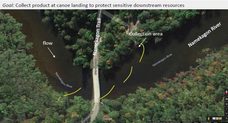
To further explain the techniques used above, refer to the image labeled NR19 – Namekagon Trail. The strategy for this location is to anchor a boom just before the Namekagon Trail, placing more booms along the Namekagon River to ensure the spilled products are directed to the canoe launch. To remove the spilled product vacuum trucks and skimmers will be needed.
If a spill occurs, it is essential to notify federal, state, and local authorities within 24-hours of the spill. To inform federal authorities, please call the National Response Center (NRC) at (800) 424-8802. To contact state authorities in Wisconsin, please call (800) 943-0003. To reach state authorities in Minnesota, please call (800) 422-0798. To contact local authorities, please call 911. For more detailed information, refer to the Upper Mississippi River Spill Response Plan.